9th February 2024
SmartDelta opens up the market for ultra-HD mobile mapping data with new SmartPano portable, low-cost/ high accuracy 360° mobile mapping system
MTi-680 motion tracking sensor from Movella enables continuous levelling and stabilisation of SmartPano’s images of road scenes
Mobile mapping is big business. Amongst other, the automotive industry relies on continually updated visual and geospatial data to enable consumer-friendly features such as satellite navigation and location-aware speed limit information. New driving assistance and automated driving functions require even more detailed data about roads and traffic. Search and mapping services for computers and mobile phones also draw on a huge global data store of geolocated images.
Until now, this mapping data has been gathered and owned by giant technology companies that deploy specialised 3D cameras mounted on dedicated vehicles. Because of the huge cost of owning and operating the cameras, mapping has been a business for those with very deep pockets.
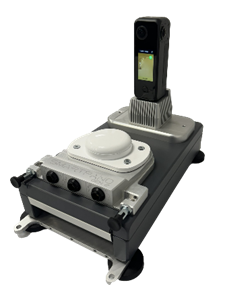
The SmartPano 360° camera from Smart Delta
The introduction of the portable and affordable SmartPano 360° camera from SmartDelta breaks down the barriers to the mapping market. The high quality and stability of the SmartPano’s images owe much to the 3D motion data produced by the Xsens MTi-680 sensor from Movella.
A new alternative to expensive, fixed 360° camera systems
The barrier to participation in the mobile mapping market has been the huge cost of the equipment. Internet search companies and other large tech companies have developed high-performance but high-cost fixed camera/sensor systems that are permanently attached to a host vehicle. Highly complex, these proprietary systems require extensive driver training before use.
Smart Delta’s development of the SmartPano camera turns the existing approaches to mobile mapping on their head. Smart Delta has created a product which is small and light enough to be easily transported anywhere in the world. The IP67 system is delivered in a hand luggage size transport case and weighs only 5.6 KG. The system has four powerful magnetic fixing cups, so it can be easily set on- and removed from the roof of any car. Wi-Fi and Bluetooth connections and 2 interconnected integrated power banks mean that the system does not need any external cables and can be operated for a full day of mapping without the need to recharge.
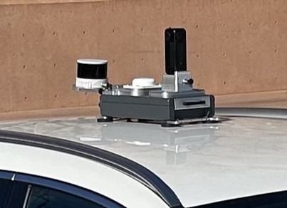
The SmartPano camera’s base has convenient magnetic cups for fixing it to the roof of a car
Crucially, the SmartPano camera system costs a fraction of the proprietary camera systems typically used for mobile mapping today.
Yet despite its size and affordability, the SmartPano camera offers geospatial video data and accuracy as good as that of an expensive proprietary system. Four Sony image sensors behind F2.28 aspherical fisheye lenses capture a sharp 360° view at a rate of 7 frames per second in 8KK (UHD) mode. The images are geolocated by a Ublox GNSS receiver.
Continuous stitching of video captured by the four image sensors requires the images to be levelled and stabilised – as though the entire camera system were mounted on a virtual gimbal. This is achieved by sophisticated SmartDelta software operating on accurate pitch and roll data produced by the Xsens MTi-680 motion tracking sensor. Tightly synchronised to the GNSS receiver and the image sensors, the MTi-680 allows the SmartPano to compensate for every bump, slope and camber in the road. The MTi-680 also provides orientation and 3D acceleration data that enables the SmartPano to maintain accurate geolocation information when it is denied a GNSS signal, such as when driving through a short tunnel.
The MTi-680 motion tracker is small enough to fit in the Smart Pano’s compact enclosure
Jan Wierenga, CCOof Smart Delta, says that the combination of high-resolution image sensors, the MTi-680 motion data, and SmartDelta software is the reason the SmartPano can match the industry’s highest standards for data quality despite being available at a fraction of the cost of Big Tech systems. “Our SmartPano system has undergone rigorous testing by one of the foremost mobile mapping data providers in the world, emerging triumphantly with exceptional quality and reliability. Positioned as an invaluable asset for mapping and location platform companies, SmartPano presents a compelling opportunity to significantly reduce the expenses associated with consistently updating high-quality road maps – meeting and exceeding the stringent demands of their discerning clientele.”

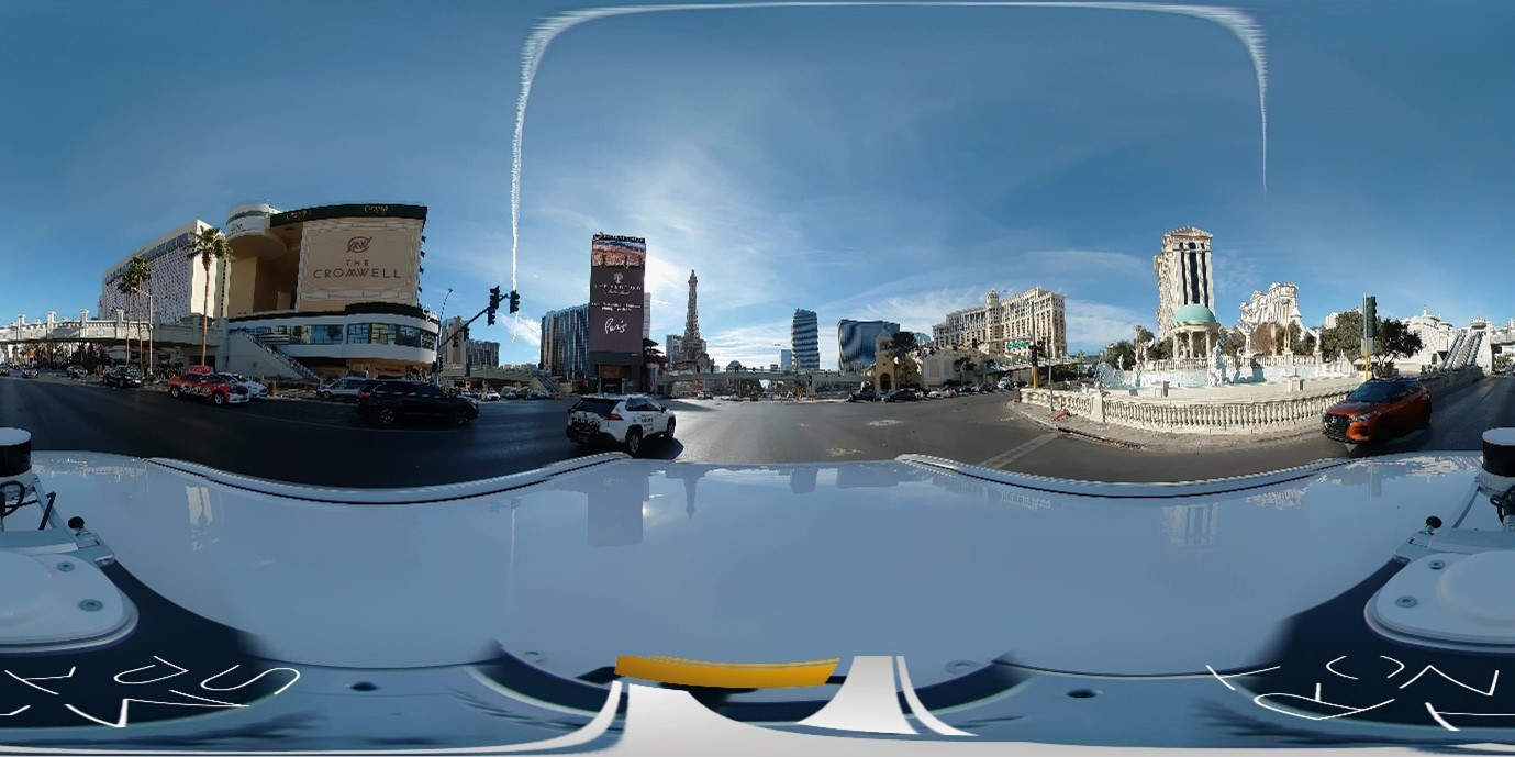
SmartPano images are seamlessly stitched to form a 360° image
The Smartpano is not only affordable to buy, but it is very scalable to operate as well.
Jan Wierenga explains: The intuitive user interface ensures any driver can operate the system without the need of any Mobile Mapping knowledge. Specific software settings to meet the customer’s requirements can be (remotely) preset and protected so that the driver can focus on his/her task.
Lidar:
When the SmartPano system itself is not sufficient, connecting a LiDAR system to the SmartPano Mobile Mapping System is a simple and intuitive action. The system is designed with user-friendliness in mind and provides seamless connectivity options for various pre integrated LiDAR devices.
This new democratisation of mobile mapping opens up many new opportunities to use the Smart- Pano’s 360° video outputs. Smart Delta sees many different applications where the Smartpano can prove its added value and welcomes potential customers to share their business case.
More information about the SmartPano 360° camera.
More information about the MTi-680 motion tracker.
Related articles